Most people fly into Quito, do the islands, and fly home. What they miss is that the adrenaline capital of Ecuador sits a bus ride from the same airport. Here's how we stack the mainland onto your Galapagos trip: what you ride, rappel, and hike, in what order, and where the altitude will catch you out.
Yes, the Galapagos stacks neatly onto a mainland-Ecuador adventure leg, and it's one of the easier combos we route because both hang off Quito. Plan 11–15 days: a 4–8-day Galapagos cruise or island stay at sea level, then 4–6 days on the mainland for canyoning and rafting in Baños (1,820 m), a trek or downhill bike on Cotopaxi (5,897 m), and the Quilotoa Loop crater lake (3,914 m). Do the mainland second so you acclimatize gradually from the islands upward. From Current departures and starting prices are in the table below.
Yes, and for an active traveler it's one of the more natural combos to route. The islands and the highland adventure belt both hang off Quito: you fly into the capital, out to the Galapagos on a short regional flight, and back through Quito again for the overland leg to Baños, Cotopaxi, and Quilotoa. The real constraint isn't distance, it's days and fitness. You need enough time on the water and enough time at altitude to do both properly, and a body that can handle a rafting run one week and a trek toward a glacier refuge the next. This isn't a stretch for our inventory either: beyond the islands, our most-booked mainland products are Ecuador Andes highland tours and Amazon rainforest trips, so folding a Baños, Cotopaxi, and Quilotoa circuit onto a Galapagos trip sits inside what we already run, not a one-off request. Land-based Galapagos time and the mainland circuit both reward a traveler who wants to keep moving rather than sit still, so the fit is closer than most first-time planners assume.
Three stops carry this leg of the trip, each at a different altitude and a different kind of physical demand. Here's the shape of it before the detail:
| Location | Signature activities | Altitude | Physical demand |
|---|---|---|---|
| Baños de Agua Santa | Canyoning / waterfall rappelling, white-water rafting on the Río Pastaza, bridge jumping (puenting), the Ruta de las Cascadas waterfall route (Pailón del Diablo), zip-lining, the Casa del Árbol swing | ~1,820 m | Moderate (rafting, canyoning) to easy (waterfall route) |
| Cotopaxi National Park | Trek to the José Ribas refuge and the glacier tongue above it, downhill mountain biking from the refuge or park road, a walk around Laguna Limpiopungo | Refuge ~4,864 m · summit 5,897 m · Limpiopungo ~3,800 m | Hard (refuge trek) to moderate (biking, Limpiopungo walk) |
| Quilotoa | The Quilotoa Loop multi-day hike through Andean villages, the ~280 m descent to the caldera, kayaking on the crater lake | Rim ~3,914 m | Moderate to hard (loop hiking); easy to moderate (kayaking) |
Baños de Agua Santa sits at roughly 1,820 m in a river gorge below the Tungurahua volcano, and it earns its adventure-sports reputation. Canyoning and waterfall rappelling drop you down cliff faces cut by feeder streams. White-water rafting runs the Río Pastaza. Bridge jumping, puenting, off the San Francisco bridge is the town's signature adrenaline photo. The Ruta de las Cascadas waterfall route strings together a run of falls, the biggest of which, Pailón del Diablo, drops through a narrow gorge you can walk almost underneath. Add zip-lining and the Casa del Árbol swing at the edge of a cliff, and Baños alone can fill several active days.
Cotopaxi National Park is built around the volcano itself, at 5,897 m one of the highest active volcanoes in the world. The standard adventure add-on isn't the summit, that's a technical, guided glacier ascent for climbers with mountaineering experience, it's the trek up to the José Ribas refuge at roughly 4,864 m and the glacier tongue just above it. Downhill mountain biking from the refuge or the park road back toward the entrance is the other headline activity, and a walk around Laguna Limpiopungo at roughly 3,800 m gives a lower-altitude alternative on the same day.
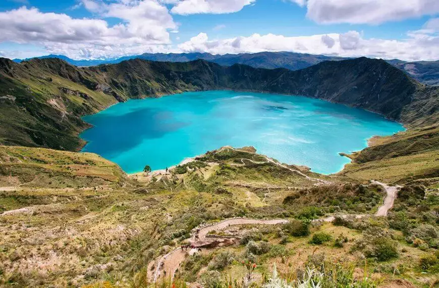
Quilotoa is a water-filled caldera at the western edge of the Andes, its rim sitting at roughly 3,914 m. The Quilotoa Loop, a multi-day hike or bike route through Andean villages and farmland, is the classic way in. From the rim, a steep descent of roughly 280 m drops you to the shoreline, where you can rent a kayak and paddle out onto crater water that shifts color with the light.
The Ecuadorian Andes are one of our own products rather than something we hand off, so the mainland leg is built and arranged by us alongside the islands, and we handle the ground logistics between the two. Exact activities and durations get set against your dates and how hard you want to push.

The altitude math is straightforward once you lay it out: the Galapagos sits at sea level, Baños at roughly 1,820 m, Quito itself at 2,850 m, the Quilotoa rim at roughly 3,914 m, and the Cotopaxi refuge at roughly 4,864 m. Fly into Quito and go straight up to the refuge, and altitude sickness is a real risk. Do the islands first, then climb the mainland gradually on the way back through Quito, and your body banks several sea-level days before it has to work at 3,800 m and above.
Within the mainland leg itself, a sensible order climbs: Baños first, the lowest point and the most physically varied day, rafting and canyoning rather than pure altitude, then Quilotoa, then Cotopaxi last as the highest and hardest day. That's not the only order that works. Some travelers prefer to front-load Cotopaxi while energy is highest and save Baños, the more forgiving day, for the end of the trip. Weather plays a role too: Cotopaxi's glacier and crater views are clearest in the drier months, so a weather window sometimes reshuffles the order regardless of altitude logic.
Don't assume the islands are the easy half of this trip and back-load every hard day onto the mainland. Surfing at San Cristóbal, sea kayaking, mountain biking on Santa Cruz, and the Sierra Negra volcano hike on Isabela are all realistic add-ons inside a Galapagos itinerary, so an active traveler can arrive at Baños already warmed up rather than starting cold. Here's how one of us frames the order question when an active traveler asks:
"I book the islands first and the mainland second, and the reason is altitude, not preference. The Galapagos is at sea level. Quito is at 2,850 metres and the highlands go up from there. Coming down is easy, going up needs a few days, so doing the islands first gives you a gentle start and lets you climb into the mainland leg gradually. Doing it the other way round means arriving at altitude on day one, jet-lagged."
— Marcelo Guerrero, Co-Owner
Here's what the routing looks like in practice, built around the islands-first order above. Every leg below is a public routing fact you can plan against: airport codes, altitudes, and the mechanics of getting from the islands to the highlands. The exact vessel or land-based program for your Galapagos days is something we confirm against live availability for your dates rather than print as a fixed default.
| Days | Location | Transfer | Altitude | Headline activity |
|---|---|---|---|---|
| Day 1 | Arrive Quito (UIO) | International arrival, overnight before the flight to the islands | 2,850 m | Settle in, adjust to Quito's altitude |
| Days 2–6 | Galapagos (via Baltra/GPS or San Cristóbal/SCY) | Regional flight from Quito, then your cruise or land-based stay | Sea level | Snorkeling, wildlife, plus island-side adventure options |
| Day 7 | Return to Quito | Regional flight islands → UIO | 2,850 m | Transfer day, one Quito night |
| Days 8–9 | Baños de Agua Santa | Road transfer from Quito, roughly 3–4 hours | ~1,820 m | Canyoning, rafting on the Río Pastaza, the Ruta de las Cascadas |
| Day 10 | Quilotoa | Road transfer from Baños | Rim ~3,914 m | Quilotoa Loop hike, kayaking on the crater lake |
| Days 11–12 | Cotopaxi National Park | Road transfer from Quilotoa | Refuge ~4,864 m | José Ribas refuge trek, downhill biking, Laguna Limpiopungo |
| Day 13 | Quito, international departure | Road transfer back to Quito | 2,850 m | Fly home |
The Galapagos leg's exact vessel, itinerary, and price-from is MyTrip auto-data we confirm against your dates rather than hand-pick here. For an active traveler, the island days aren't just wildlife-watching between mainland legs, they carry their own adventure menu: surfing at San Cristóbal, sea kayaking, mountain biking on Santa Cruz, and the Sierra Negra volcano hike on Isabela are all realistic parts of a Galapagos itinerary. See our adventure sports in the Galapagos Islands hub and the active Galapagos multisport collection for the full island-side menu.
Thirteen days is the middle of the range, not the only option. An 11-day compressed variant covers the Galapagos plus Baños and Cotopaxi only, dropping Quilotoa. A 15-day extended variant adds the full Quilotoa Loop, or trades a mainland day for an Amazon leg, see our Galapagos and the Amazon rainforest guide for how that pairing works.

There's no direct flight or boat link between the islands and the highlands; every routing goes through the mainland. Avianca and LATAM fly the regional leg between Quito or Guayaquil and the islands' two airports, Baltra (GPS) and San Cristóbal (SCY). Coming back from the islands, you land in Quito or Guayaquil and continue overland from there, there's no shortcut that skips the capital.
Before you fly out to the islands, you'll need the mandatory Galapagos transit control card, the INGALA card ($20, bought ahead of the flight), and you'll pay the Galapagos National Park entry fee ($200) on arrival. Neither applies once you're on the mainland leg. The mainland ground transfers are road legs: Quito to Baños runs a few hours south into the Andes, and Baños to Quilotoa and on to Cotopaxi adds more road time through smaller mountain towns, most travelers book these as private or shared transfers rather than self-drive. For more on the Baños side specifically, see our Baños travel guide and tips, and for the wider mainland-adventure inventory, our Ecuador multisport adventure page.
The Galapagos leg prices the way any Galapagos trip does: roughly $2,500–$3,500 budget, $3,500–$6,000 mid-range, and $6,000–$12,000+ luxury per person on double occupancy for a 4–8-day cruise or land-based stay, plus the fixed government costs everyone pays, the $200 park entry and the $20 INGALA card. The mainland leg is a separate quote on top, priced by hotel tier in Baños and near Quilotoa, plus the activity fees for canyoning, rafting, the Cotopaxi trek, and the guide and gear that come with them. Here's how one of us answers the cost question we hear most from combo travelers:
"The mistake is treating the mainland leg as filler between the flights. It is not filler, it is the hardest part of the trip physically, and people show up for Cotopaxi expecting a stroll. You do not need to be a mountaineer for the refuge walk, but you do need to respect the altitude and be straight with us about your fitness, because the summit climb is a genuinely different proposition and not everyone should be doing it."
— Evelyn Duran, Co-Owner
Current departures and starting prices are in the table below. What's excluded from that figure: your international flight into Ecuador, travel insurance, and any Cotopaxi summit-climb add-on, which prices separately since it needs mountaineering gear and a specialist guide most travelers don't need for the refuge trek alone. What's included once you book the combo through us: both legs' flights where we're ticketing them together, your Galapagos naturalist guide and park logistics, and the mainland guide and equipment for the canyoning, rafting, and Cotopaxi legs.
The Quilotoa Loop and the Cotopaxi refuge trek both sit above 3,800 m, and moderate at that altitude means something different than moderate at sea level. You don't need mountaineering experience for either, that's the technical summit climb, but you do need a baseline of cardiovascular fitness and the patience to walk slower than you would at home. Regular hikers and anyone comfortable on a multi-day trek will manage both. Travelers who arrive unfit, or who skip acclimatization entirely, tend to cut the Cotopaxi day short.
Hydrate more than feels necessary, ascend gradually rather than jumping straight to the highest point, and build in the buffer a Quito night or two gives you before the highest days. Doing the islands first, as covered above, does real acclimatization work on its own, since you spend four to eight days at sea level before climbing back up through the Andes.
On timing, the two halves of this trip run on different calendars. The Galapagos works year-round: December through May runs warmer and wetter with calmer seas, June through November runs cooler and drier with more marine life activity. The mainland highlands favor June through September for Cotopaxi, when drier weather means clearer summit and crater views; Baños's canyoning and rafting run year-round regardless. The overlap where both halves are at their best is roughly June through September, though a well-planned trip works in most months if you're flexible on which Galapagos itinerary you take.
Talk with an expert insider — we'll build your Galapagos + mainland adventure route in 24 hours.
USA & Canada 1-773-280-9571 · Ecuador +593-987-004-404 · [email protected]
Yes, and it's one of the easier combos we route, since both halves hang off Quito. Plan 11 to 15 days total: four to eight days in the Galapagos, four to six on the mainland for Baños, Cotopaxi, and Quilotoa. The constraint is days and fitness, not distance, everything connects through a single mainland hub rather than a long detour.
Plan 11 to 15 days. An 11-day version covers the Galapagos plus Baños and Cotopaxi only; 15 days adds the full Quilotoa Loop or leaves room for an Amazon extension. Inside that, figure four to eight days for the islands and four to six for the mainland circuit, plus a buffer night in Quito on either side of the flights.
We recommend the mainland second. Starting at sea level in the Galapagos and climbing the Andes afterward gives your body several easy days before it has to work at 3,800 m and above. Doing Quito and the highlands first, with no acclimatization buffer, is where altitude catches active travelers who assumed fitness alone would cover it.
There's no direct link, every route goes through the mainland. You fly Avianca or LATAM between the islands (Baltra or San Cristóbal) and Quito or Guayaquil, then continue overland from Quito: a few hours by road south to Baños, then on to Quilotoa and Cotopaxi. Most travelers book these mainland transfers as part of the package rather than self-drive.
You don't need mountaineering experience for the Quilotoa Loop or the Cotopaxi refuge trek, that's the technical summit climb, but you do need reasonable cardiovascular fitness and the patience to move slower at altitude than you would at sea level. Regular hikers manage both comfortably; travelers who skip acclimatization tend to cut the Cotopaxi day short.
Baños sits at roughly 1,820 m, Quito at 2,850 m, the Quilotoa crater rim at roughly 3,914 m, and the José Ribas refuge on Cotopaxi at roughly 4,864 m, with the volcano's summit at 5,897 m. The Galapagos, by contrast, is sea level throughout, which is why we recommend doing the islands first.
Baños offers canyoning, waterfall rappelling, white-water rafting on the Río Pastaza, bridge jumping, and the Ruta de las Cascadas waterfall route. Cotopaxi National Park has the José Ribas refuge trek, downhill mountain biking, and a walk around Laguna Limpiopungo. Quilotoa has the multi-day Quilotoa Loop hike, a descent to the crater lake, and kayaking on the water.
Live availability and starting prices for our Galapagos departures. Dates and rates update automatically.
Tell us your dates and how many mainland days you want, and we'll come back within 24 hours with a real route: the order that fits your trip, the flights that connect it, and one combined number for both legs, land and regional air. No pressure, no boilerplate.
USA & Canada 1-773-280-9571 · Ecuador +593-987-004-404 · [email protected]
Want more active options inside the islands themselves? Start with our adventure sports in the Galapagos Islands hub. Adding the Amazon to a longer trip? See Galapagos and the Amazon rainforest. Ready to browse? See all Galapagos cruises and tours and our Ecuador multisport adventure page.